


Data Processing & Application
Satellite and in-situ data acquired by the members and facilities at the center are processed and analyzed with cutting-edge technologies that are developed at the center. Such technologies include deep learning, Interferometric SAR(Bi-/Multi-Static SAR), Polarimetric SAR(PolSAR), signal processing, and data fusion in addition to other in-house algorithms and models. The data processed for various applications and analysis results from the data are utilized mainly for disaster monitoring, environmental change monitoring, and safety inspection.
Deep learning
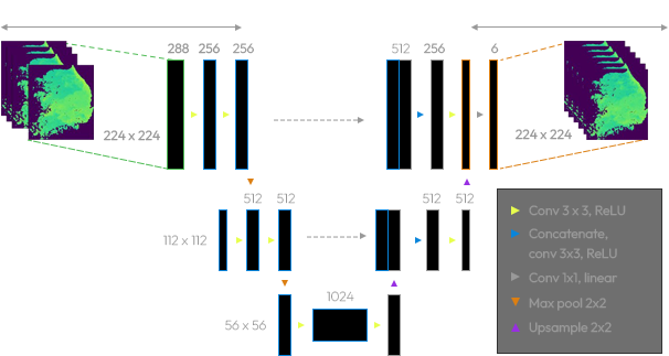
Deep learning
For high efficiency in disaster and situation awareness, Deep learning model with a high detection rate is used. In addition, using various deep learning models such as CNN and GAN to train various types of satellite data, it can be operated without exception in practice. Deep learning models are used for ship detection, oil spill detection, forest fire detection, flood detection, and high-resolution image reconstruction. These learning models are trained based on a large amount of training data.
PolSAR
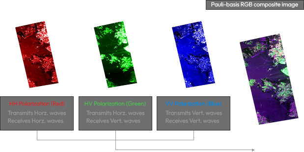
PolSAR
Polarization refers to the property of the radiated electromagnetic wave describing a time-varying direction and relative magnitude of the electric wave vector. Polarimetric SAR satellites can collect polarimetric properties of the observed surface, which can reveal the detailed information such as structure, orientation and other environmental conditions of the incident surface. Polarimetric studies have several applications including shipping, hydrology, forestry and coastal zone.
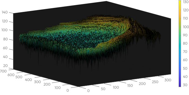
InSAR
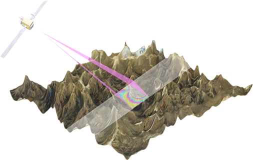
InSAR
Interferometric Synthetic Aperture Radar (InSAR) is a radar technique analyzing phase changes, which is used in geodesy and remote sensing. This algorithm calculates phase differences between two SAR images and extracts a specific phase information, such as target displacement. It can be applied to monitor structure stability and natural or man-made ground motion, such as earthquake and ground subsidence caused by ground water extraction.
This technique is also used to precisely monitor the safety of various infrastructures such as bridges, ports, railroads, and power generation facilities.
Signal Processing
Signal Processing
Signal Processing is the process of a digital signal to make or improve its performance and accuracy. Signal Processing of SAR Data utilizes doppler shift frequency to make high-resolution imagery using mathematical tools such as Fourier transform, convolution and interpolation. Digital Signal Processing such as Back Projection Algorithm, Range Doppler Algorithm, Along Track Interferometry, Optimized Range Cell Migration, etc., are being researched. Advanced SAR signal processing techniques can get high resolution images and perform more fast operation processing.
Data Fusion
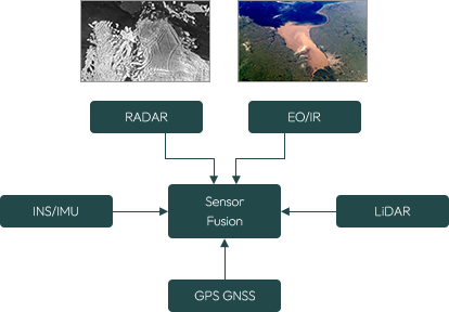
Data Fusion
Fusion of data from multi sensors is the process of combining different types of data derived from Radar, EO/IR, LiDAR, etc., to form a unified image. More accurate and detailed information can be acquired through data fusion research. Sensor fusion techniques can provide higher accuracy and reduce the impact of noise compared with a single sensor. This research is applied to various fields such as autonomous driving, Earth observation, global navigation system etc. Utilizing Multi Sensors makes it possible to provide reliable and high-quality information by complementing sensors each other.

