


Data Processing & Application
Satellite and in-situ data acquired by the members and facilities at the center are processed and analyzed with cutting-edge technologies that are developed at the center. Such technologies include deep learning, Interferometric SAR(Bi-/Multi-Static SAR), Polarimetric SAR(PolSAR), signal processing, and data fusion in addition to other in-house algorithms and models. The data processed for various applications and analysis results from the data are utilized mainly for disaster monitoring, environmental change monitoring, and safety inspection.
Flood mapping / Flood
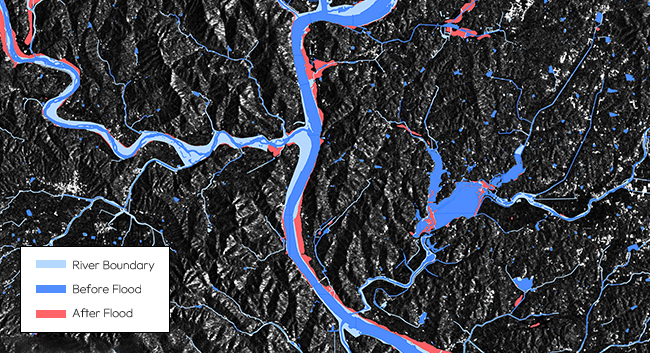
Flood mapping / Flood
SAR has been considered to be suitable for flood monitoring, which is almost independent from cloud cover, sunlight and other weather conditions. Using specular reflecting characteristics of water in the microwave spectrum, we are able to detect whether there is water or not regardless of river boundaries. The area that is detected as water and exceeds the river boundary is classified as a flooded area.
Oil spill
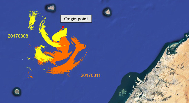
Oil spill
Effective oil spill response with oil information in a timely manner is important, considering the detrimental effect of oil spill on the marine ecosystem. SAR, as an active sensor that can operate day and night, has been widely utilized for oil spill characterization. Oil attenuates ocean waves, which appear as a dark spot in SAR imagery. Characteristics of oil spills, such as area of pollution and outflow of oil, can be calculated through the dark spot image.
Earthquake / volcanic activity / ground displacement
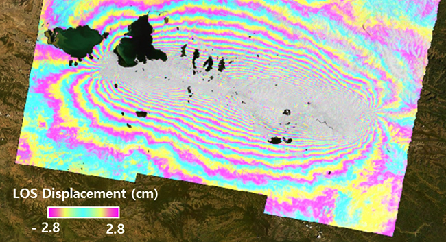
Earthquake / volcanic activity / ground displacement
Volcanic activity or earthquake referred as natural disaster, and artificial ground water extraction usually involve ground surface movement during entire period. Monitoring of structure stability and ground motion from these hazards must be performed to prevent disaster loss. Differential Interferometric Synthetic Aperture Radar (D-InSAR) and Time-Series Interferometric Synthetic Aperture Radar (TS-InSAR) can provide precise and detailed ground displacement with satellite SAR data acquired in a short period of time.
Forest Fire
Precise forest monitoring is essential for climate change assessment and sustainable development. SAR plays an important role in quantifying and mapping deforestation and forest degradation. Subtle changes of the trees can be detected by analyzing backscatter variations from the forest, as the structure and moisture of an object affect SAR backscatter signal.
Forest Fire
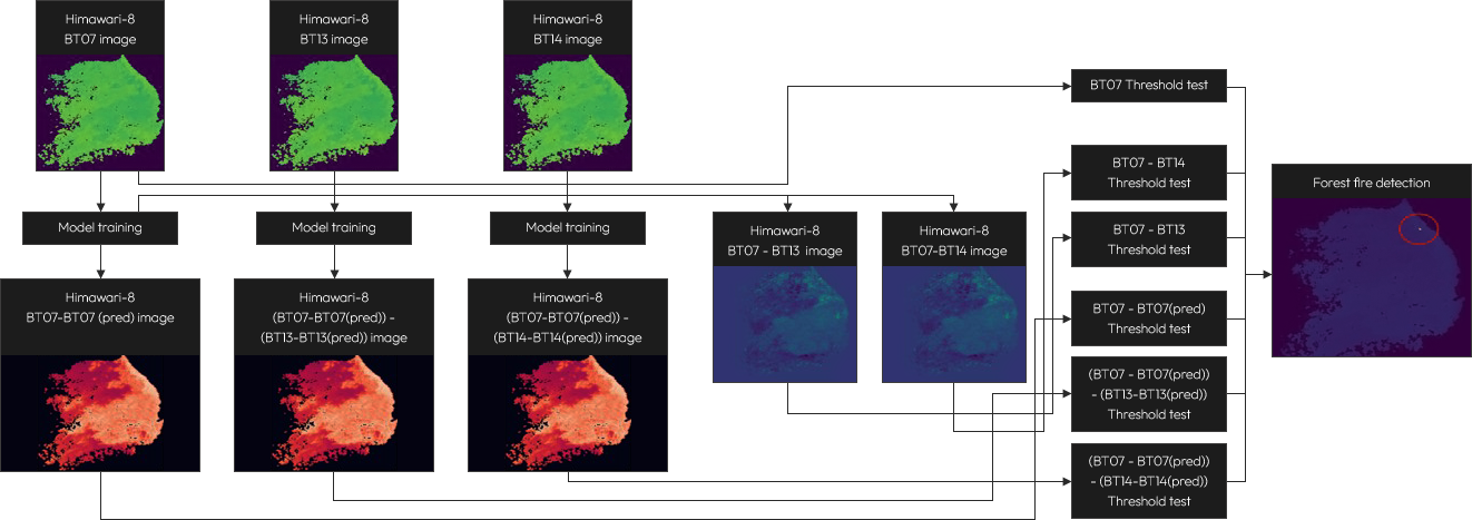
Precise forest monitoring is essential for climate change assessment and sustainable development. SAR plays an important role in quantifying and mapping deforestation and forest degradation. Subtle changes of the trees can be detected by analyzing backscatter variations from the forest, as the structure and moisture of an object affect SAR backscatter signal.

