


Data Processing & Application
Satellite and in-situ data acquired by the members and facilities at the center are processed and analyzed with cutting-edge technologies that are developed at the center. Such technologies include deep learning, Interferometric SAR(Bi-/Multi-Static SAR), Polarimetric SAR(PolSAR), signal processing, and data fusion in addition to other in-house algorithms and models. The data processed for various applications and analysis results from the data are utilized mainly for disaster monitoring, environmental change monitoring, and safety inspection.
Glacier
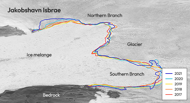
Glacier
The boundary between ice mélange and glacier is a sensitive indicator of glaciological and environmental changes. Glacier calving fronts can be delineated by using SAR images which are not affected by weather conditions. Applying the CNN-based deep learning model, we can automatically detect calving fronts continuously in time series, providing data that can be utilized for global environmental monitoring.
Sea ice
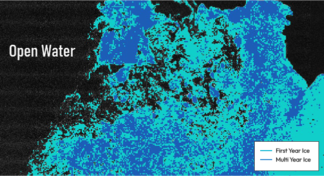
Sea ice
Generation of an accurate polar sea ice map demonstrating the distribution and area is important to pioneering arctic naval routes. Using CNN-based deep learning algorithm is able to obtain the distribution of different sea ice thickness at polar sea surface. The polar sea ice detection algorithm can be applied in generating high-resolution maps of polar sea ice, pioneering arctic routes, navigation safety and climate changes.
Sea level change
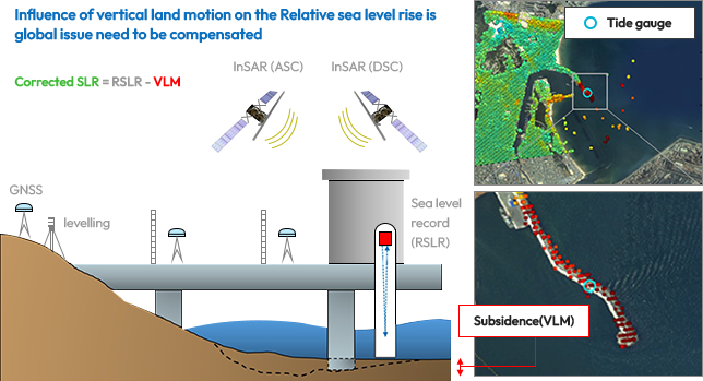
Sea level change
Rising sea level due to climate change affects the low lying coasts that lead to sinking of cities, which indicates this phenomenon should be monitored carefully. Satellite-based SAR interferometry techniques can measure the vertical ground motion at tide gauges to calculate sea level changes more accurately. With different time-series InSAR algorithms including PS-InSAR, SBAS and Sequential-SBAS, Spatially dense and high temporal displacement with mm/year accuracy can be obtained in the vicinity of tide gauges.
Tidal flat
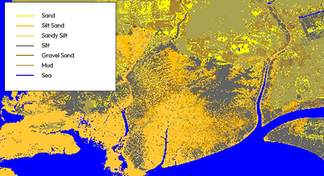
Tidal flat
Since tidal flats are attracting attention in terms of ecological value, related experience activities are increasing. Drowning accidents by unknown locations of tidal channels are also a big problem. Produce a topographic map of tidal flat with DEM generation using spaceborne SAR. Develop thematic mapping technologies of tidal flat including tidal channel mapping method and tidal sedimentary facies mapping method.
Forest
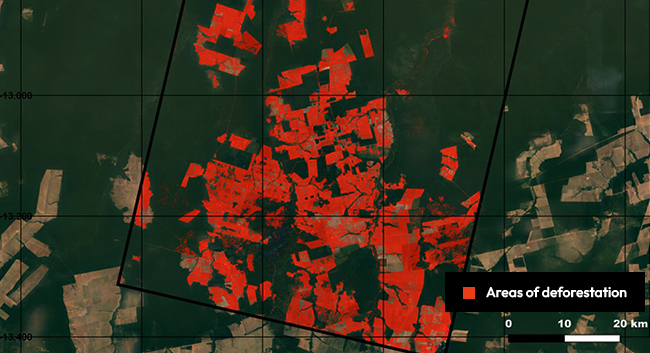
Forest
Detailed forest monitoring is essential for climate change assessment and sustainable development. Monitoring methods such as mapping deforestation, forest degradation and detecting the changes of productive area for tree species could be implemented by SAR technology. Since the structure and moisture of the object affect SAR backscatter signal, any changes in the forest can be detected by analyzing backscatter variations from the forest.

